Satellite Company Restricts Iran War Imagery at US Government Request
Planet Labs halts distribution of satellite images over Iran citing US government request for security reasons, hampering press coverage of the conflict and independent verification efforts.
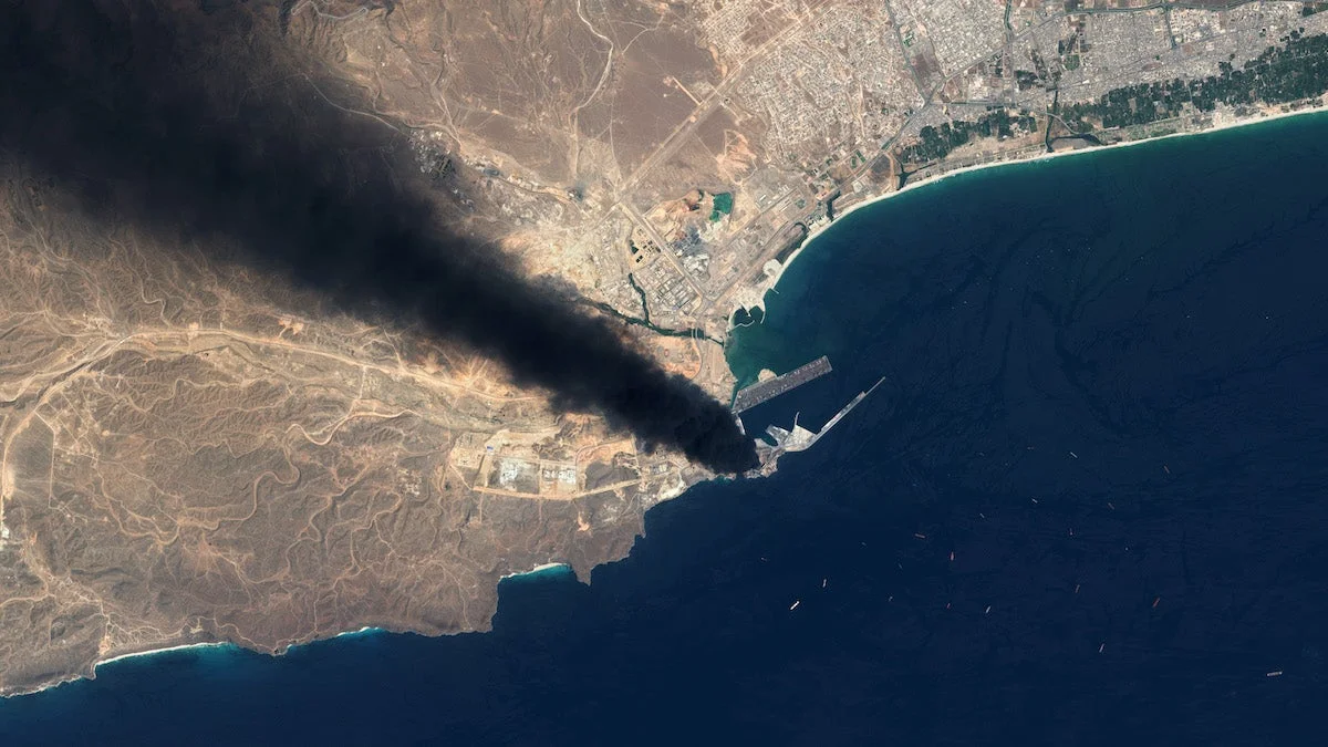
Planet Labs, a major commercial satellite imagery provider serving news organizations and researchers worldwide, announced on Saturday that it is indefinitely restricting access to satellite imagery covering Iran and surrounding conflict zones. The decision comes following a request from the U.S. government, as reported by the New York Times.
The company stated that the government made its request citing "safety and operational security reasons." Under the new policy, Planet Labs will "voluntarily withhold imagery over the area indefinitely until the conflict ends" and implement a "managed distribution" system instead. This means satellite images will only be released on a limited, case-by-case basis when deemed mission-critical or serving the public interest.
The policy change represents a significant restriction on one of the few widely available tools used by journalists, researchers, and independent analysts to verify military strikes, assess damage, and track developments in areas that are difficult or dangerous to access. Multiple affected media outlets have expressed concern that the measure will substantially hamper their ability to document events in the region.
The Pentagon declined to comment on whether it had specifically requested satellite companies to restrict imagery from the region. However, the timing and scope of Planet Labs' decision suggest coordination with government officials focused on preventing sensitive military information from becoming public.
The restricted area under the new policy encompasses all of Iran, Gulf states, and other active conflict zones throughout the Middle East region. Additionally, Planet Labs is extending publication delays for all imagery and data collected since March 9, moving beyond its previous March restriction that imposed a 14-day delay on Iranian imagery.
This development reflects a broader trend among satellite data providers as regional tensions escalate. Other imagery companies have recently implemented new delays or tighter controls on Middle East data access, though not all have attributed these measures to direct U.S. government requests.
Commercial satellite imagery has become increasingly central to modern conflict coverage, enabling reporters, open-source investigators, and human rights organizations to independently verify events on the ground. The restrictions now imposed by major providers like Planet Labs significantly reduce transparency and public access to information about military operations in the region.