


Urgent Snowstorm Warning Issued for Central Indiana This Week
UPDATE: Central Indiana is bracing for a significant snowstorm beginning Thursday night and continuing into early Friday morning. Authorities warn that gusty winds will usher in colder temperatures, with lows dropping to the mid-20s Fahrenheit. The forecast indicates that the snow could heavily impact the evening commute, making travel conditions hazardous.
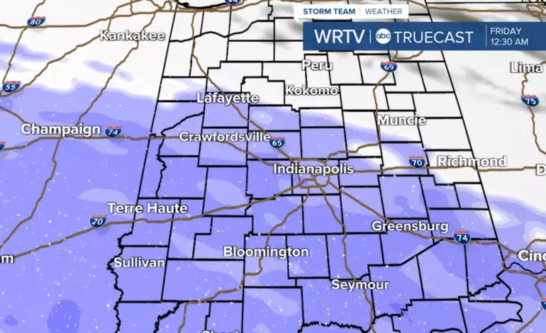
As of now, weather models project 1 to 3 inches of snow along and southwest of a line from Lafayette to Richmond, with potential accumulations of 3 to 5 inches in central and southern areas. Wind gusts will decrease overnight, but the chill will remain significant. Thursday is expected to be predominantly gray, with temperatures only reaching the low 30s during the day, bringing a mix of flurries, especially in the morning.
This winter weather system is set to move in by Thursday evening, and snow will begin to blanket Central Indiana. Residents are advised to stay updated, as conditions could change rapidly. Friday’s forecast shows a continuation of mostly cloudy skies with a high near 33°F.
In addition to Thursday’s snow, another system could bring light snow on Saturday, coupled with the coldest air of the season. Highs could plunge to the single digits on Sunday, with dangerous wind chills expected.
Residents are urged to prepare for shifting weather conditions and to plan accordingly for the upcoming travel disruptions. Stay tuned for updates from the WRTV Storm Team as this developing weather situation unfolds.
Indianapolis Weather Forecast:
– **Tonight:** Cloudy, low of 25°F
– **Thursday:** Cloudy with possible flurries, high of 31°F
– **Thursday Night:** Snow likely, low of 26°F
– **Friday:** Mostly cloudy, high of 33°F
– **Saturday:** Light snow likely, high of 19°F
Residents are encouraged to check local updates and stay safe as the winter storm approaches.