

Texas Floods Surge as Storms Merge, Claiming Over 100 Lives
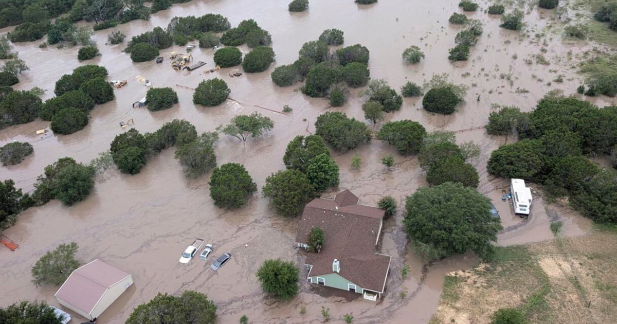
Severe flooding in Texas’ Hill Country has resulted in over 100 fatalities, driven by a combination of extreme weather conditions and geographical factors. A series of thunderstorms, intensified by the remnants of Tropical Storm Barry, unleashed catastrophic rainfall, with some areas receiving between 10 to 12 inches in a mere six hours.
The National Oceanic and Atmospheric Administration’s (NOAA) tools registered unprecedented rainfall levels, with models indicating that rainfall rates reached alarming thresholds. David Gagne, a scientist at the National Center for Atmospheric Research, described the situation as a “worst-case scenario,” emphasizing that the storms struck at a critical time during a holiday weekend when many were outdoors.
Storm Dynamics and Local Geography Contribute to Disaster
The thunderstorms stalled above the South Guadalupe River Basin, a region notorious for flooding. John Nielsen-Gammon, Texas’ state climatologist, pointed out that the storm’s trajectory was particularly detrimental. “If the storm had been even five miles in another direction, it would not have produced as much destruction,” he noted.
Despite advancements in weather forecasting, existing models struggled to predict the exact locations where the heaviest rainfall would occur. Nielsen-Gammon highlighted the limitations of current systems, stating that it is “next to impossible” to foresee whether successive storms would linger over a specific area. The alerts issued by the National Weather Service (NWS) provided only a few hours’ notice for residents to evacuate.
Historically, Texas has experienced a high number of flood-related fatalities. According to research conducted by Hatim Sharif from the University of Texas at San Antonio, the state recorded 1,069 flood deaths from 1959 to 2019, significantly more than any other state. Many of these incidents occurred in the Hill Country, an area often referred to as “flash flood alley.”
The Impact of Topography on Flooding Severity
The unique geography of the Hill Country, shaped by the Balcones Escarpment, exacerbates flooding risks. This fault zone creates a barrier that forces moist air from the Gulf to rise, often resulting in thunderstorms. Sharif explained how the region’s steep hills and narrow canyons funnel water rapidly into larger waterways, contributing to swift flooding. “It doesn’t take a lot of time to flood those creeks,” he stated, noting that the shallow soil overlaying bedrock limits water absorption.
On the morning of the flood, the Guadalupe River rose by approximately 20 feet in just over twelve hours, transforming from a calm stream into a torrent. This rapid rise in water levels further complicated rescue efforts and response measures in the region, where many campers and residents found themselves in peril.
The tragic events underscore the urgent need for improved forecasting models and infrastructure to better predict and manage such extreme weather events. As communities recover from this disaster, the focus will likely turn to enhancing early warning systems and ensuring that residents receive timely alerts to mitigate future risks.