
Researchers Use AI to Decode Mars’ Wind History Through Sand Dunes
An innovative technique developed by researchers at the State University of Campinas in Brazil is paving the way for scientists to understand how winds have shaped the surface of Mars. By measuring the forces acting on individual grains of sand, the team aims to uncover the planet’s atmospheric history, one grain at a time.
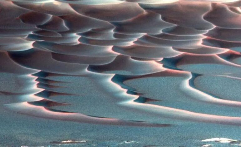
The method hinges on analyzing images of dune surfaces to estimate the forces impacting each grain. This approach combines laboratory experiments, computer simulations, and artificial intelligence (AI) to create detailed force maps that elucidate the physics of dune formation. Dunes, especially crescent-shaped barchan dunes, form wherever wind or water interacts with loose sand, from the deserts on Earth to the dusty plains of Mars.
Understanding these formations provides insights into prevailing winds and environmental conditions. However, quantifying the forces acting on each grain had previously been a significant challenge. “To measure the force acting on each grain, you’d need to place a tiny accelerometer on each one, which simply doesn’t exist,” stated the research team.
To overcome this obstacle, the researchers recreated miniature underwater dunes in a controlled laboratory environment. They conducted extensive 3D simulations to determine the specific forces at play on each grain. Subsequently, they trained a convolutional neural network, a form of AI adept in image recognition, to correlate dune images with the corresponding force maps generated from the simulations. This training allowed the AI to predict force distributions from visual data alone.
The AI demonstrated its capabilities when tested on new images, accurately predicting the forces acting on dune shapes it had not encountered during training. “Any granular system that can be seen in an image — whether ice, salt, or synthetic particles — can be analyzed as long as there’s a simulation capable of accurately reproducing the behavior of the material,” explained Renato Miotto, the study’s lead author.
The implications of this technique extend beyond planetary research. On Earth, it could enhance predictions related to coastal erosion, river sediment transport, and the behavior of granular materials in various industrial systems. The methodology’s application to other planets, like Mars, is particularly compelling, as it can yield insights into past wind intensity and the potential evolution of dunes in the future.
“This method offers a new window into studying the Red Planet’s atmospheric history and surface evolution,” noted Erick Franklin, a professor and co-author of the study. The findings were published in the journal Geophysical Research Letters on August 1, 2023.
As researchers continue to explore the Martian landscape, the ability to extract detailed physical information from images alone may revolutionize our understanding of not just Mars, but other celestial bodies as well. The forces that shape these environments are now becoming clearer, revealing the history of winds that have swept across the Red Planet for millennia.