

Earth Unexpectedly Appears in Stunning Satellite Image of the Sun
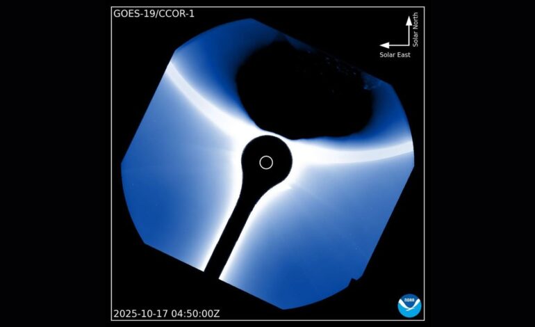
A recent image captured by the U.S. National Oceanic and Atmospheric Administration’s (NOAA) weather satellite, GOES-19, features an unexpected sight: Earth appearing at the edge of a photograph of the sun. This remarkable image was taken using the satellite’s CCOR-1 coronagraph, which is designed to monitor solar activity, including the solar corona that extends millions of miles into space.
GOES-19 is part of the Geostationary Operational Environmental Satellite series operated by NOAA. Launched in 2024 and declared operational in early 2025, this satellite continuously observes Earth’s weather and the surrounding space environment from its position approximately 22,000 miles (or 36,000 kilometers) above the equator. This geostationary orbit allows the satellite to maintain a constant view of specific areas on the planet.
The image shared by NOAA’s Space Weather Prediction Center on social media highlights Earth’s silhouette against the bright solar corona, a phenomenon usually invisible to the naked eye. The corona is critical for understanding solar events, as it is the source of coronal mass ejections (CMEs), which can disrupt satellites, power grids, and communication systems when they reach Earth.
This particular photograph serves a dual purpose. While it may appear as a mere coincidence of timing—Earth “photobombing” the sun—it actually confirms that the CCOR-1 instrument is functioning effectively. Its sensitivity enables it to capture faint solar structures even when a bright object like Earth enters its field of view.
Moreover, the appearance of Earth in the image provides valuable data for scientists. It allows for calibration tests that help researchers understand how the CCOR-1 manages stray light, reflections, and the contrast in brightness between different celestial bodies. These insights are essential for improving solar monitoring capabilities.
For those interested in the technical aspects, coronagraphs like CCOR-1 are pivotal in solar observation. They are designed to block out the sun’s intense light, allowing for clear imaging of the corona and other solar phenomena. This technology is vital for predicting space weather events that can have significant impacts on our daily lives.
In conclusion, while the sight of Earth in the satellite image may be surprising, it underscores the advanced capabilities of NOAA’s satellite technology and the importance of ongoing solar research. As scientists continue to analyze this stunning photograph, it will contribute to a better understanding of the sun’s behavior and its effects on our planet.