

Typhoon Wipha Hits Hong Kong and Macau with 106 MPH Winds
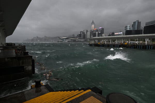
UPDATE: Typhoon Wipha is currently battering Hong Kong and Macau with devastating rain and winds, reaching speeds of up to 106 miles per hour. As of July 16, 2023, the storm is approaching mainland China with the intensity of a Category 2 hurricane, prompting urgent warnings from authorities.
The Hong Kong Observatory issued a No. 10 hurricane signal—the highest possible warning—for the first time since 2023. Macau has raised a similar alert, urging residents to remain indoors and away from windows due to the risk of flying debris.
As Wipha skirts the southern edge of Hong Kong, heavy showers and dangerous sea swells have already begun to impact daily life. At Hong Kong International Airport, over 400 flights have been rescheduled, while nearly 200 flights have been canceled at Macau International Airport, according to reports from local authorities.
The storm is projected to move west toward Macau, with landfall anticipated between the southern Chinese cities of Shenzhen and Zhanjiang later today. The Guangdong meteorological service has confirmed that Wipha is expected to make landfall with sustained winds equivalent to a Category 2 hurricane.
In preparation, Zhuhai, a city of approximately 2.5 million residents, has closed parks, construction sites, and other outdoor facilities. Authorities have also suspended ferry services and trains in anticipation of severe weather conditions. Zhanjiang has followed suit, closing schools and some workplaces.
Residents are advised to stay informed through official channels as the storm progresses. After striking southern China, Wipha is expected to continue its trajectory offshore, potentially making landfall in Vietnam.
As this situation develops, stay tuned for updates. The impact of Typhoon Wipha is being felt across the region, with serious implications for safety and transportation.