

Atlantic Hurricane Season Stuns with Zero Storms for Weeks
UPDATE: The Atlantic hurricane season is experiencing an unprecedented lull, with not a single named storm forming in nearly three weeks. As meteorologists and residents alike question, “Where are the Atlantic #hurricanes?” the peak of hurricane season remains eerily calm.
According to Philip Klotzbach, a meteorologist at Colorado State University, this unusual pattern is raising eyebrows. The last named storm was Tropical Storm Fernand, which formed on August 23 and dissipated just five days later, leaving scientists baffled. This marks only the second time since modern record-keeping began in 1950 that no named storms have occurred during this critical period.
Meteorologist Ernesto Rodríguez from the National Weather Service office in San Juan, Puerto Rico, explains, “Usually, conditions during this period are prime.” The quietest peak recorded was in 1992, following the devastation of Hurricane Andrew in Florida.
Why is this happening now? Three main factors are at play:
1. A strong vertical wind shear is disrupting storm formation.
2. Persistent dry air enveloping the tropical Atlantic.
3. A significant drop in rainfall in West Africa, where tropical waves typically develop.
Rodríguez commented, “This is pretty positive, especially for us in Puerto Rico,” where residents are still recovering from Hurricane Maria, a catastrophic Category 4 storm that struck on September 20, 2017.
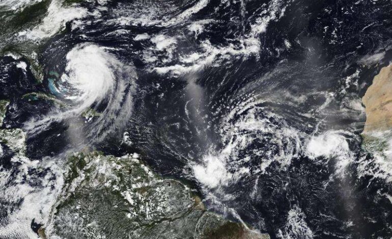
Despite the current calm, experts warn that the season is not over yet. Forecasters anticipate that a cluster of storms currently forming over hundreds of miles east of the Caribbean could become a named storm in the coming days. However, initial predictions suggest it will move away from land, likely remaining over open water.
Rodríguez highlighted that from September 15 to October 15, conditions are expected to become more favorable for storm development as ocean temperatures remain warm, providing essential fuel for hurricanes.
Historically, up to 80% of hurricane activity occurs in August and September, yet this year has only seen six named storms. A report from Colorado State University notes that “insufficient instability” has plagued the Atlantic this season, contradicting earlier predictions of an above-normal season with 13 to 18 named storms expected.
The National Oceanic and Atmospheric Administration (NOAA) forecasted that among these, five to nine would strengthen into hurricanes, with two to five classified as major hurricanes. This season’s first hurricane, Erin, reached Category 5 status in August but has since been the only significant storm.
As the situation unfolds, meteorologists continue to monitor conditions closely. While a secondary cluster of storms is trailing behind with only a 20% chance of formation, the potential for a busy period remains.
The Atlantic hurricane season, which officially runs from June 1 to November 30, typically generates around 14 named storms, with approximately seven evolving into hurricanes. Hurricane specialist Michael Lowry remarked that the usual “conga line of tropical waves exiting Africa” is noticeably delayed this season.
As residents and meteorologists alike hold their breath, the world watches closely for any sign of the storms that typically define this time of year. Stay tuned for further updates on this developing story.